
FAQs
What are the benefits of the project?
· It supports active and healthy lifestyle choices by encouraging more people to walk and cycle to local destinations such as Centennial Park, the Light Rail and University of New South Wales.
· It will physically separate people cycling from those who walk, and from cars. This makes the street safer for everyone.
· More people choosing to ride and walk for local trips helps ease congestion and parking demands.
· The street will benefit from improvements such as traffic calming, new pedestrian crossings and pram ramps, making the street safer for local walkers.
· New trees and landscaping along the route.
· It aligns closely with Council’s 20 Year City Plan to build a network of safe and convenient walking paths and cycleways.
· It connects to existing local and regional bike routes, and has been identified as a priority route in the NSW Active Transport Program.
· It was identified in our 2015 consultation as the highest priority route in Randwick City’s local cycle network.
How does a separated cycleway work?
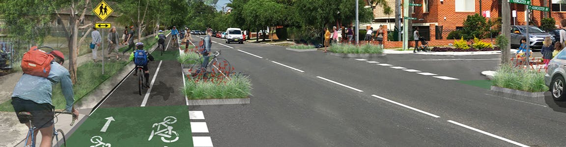
Separated cycleways are dedicated spaces located in between the lane used for street parking or traffic, and the footpath. They provide a two-way travel lane for riding a bicycle that is separate from moving traffic and from the footpath. Separated cycleways are widely considered to be much safer than riding on the road.
Why has this route been chosen?
Doncaster Ave and Houston Rd are currently well-used by pedestrian and bike riders. They link Kingsford with Centennial Park, and paths to the Sydney CBD.
Community consultation took place in 2015 to identify and prioritise the construction of cycling routes across the LGA. This route was identified as the number one priority.
The route also aligns with NSW Government plans for key strategic cycling corridors.
What is the width of the cycleway?
The cycleway is 2.4m wide along most of the route, meaning each cycle lane is 1.2m. The width can generally be accommodated in the road corridor without loss of footpaths, car parking or travel lanes.
What will happen to the trees?
Improving planting along the route by providing additional planter beds and trees has been a key priority for the project.
Some trees are proposed to be removed to accommodate traffic changes or improve safety, however there will be an increase of around fifty additional trees overall.
Will it affect public parking space near me?
Although every effort has been made to retain parking along the route, some spaces have been lost to accommodate new pedestrian crossings and the like. New spaces have been created where possible. Overall there is a loss of 20 spaces along the full length of the route, being a removal of 34 spaces, with 14 new spaces created to offset these losses.
How will the cycleway integrate with traffic lights?
All signalised intersections will be designed with bike riders in mind, and be developed in detail with Roads and Maritime Services.
Will the traffic lanes change?
The detailed plans on exhibition show any proposed changes to current traffic arrangements.
Who’s funding it?
The design development of the project is fully funded by Roads and Maritime Service (RMS). It is anticipated that construction funding will be fully funded by RMS too.
When will construction take place?
Planning and consultation is taking place in 2018. The timing of construction is not yet set and construction funding has yet to be received. Any construction wouldn’t take place before mid-2019.
How long will it take to build and will it be staged?
Construction isn’t currently funded. However it is likely be built in stages, which means the construction impact on individual properties will be minimised. Overall construction of the entire route will be complex and likely take many months. The community will be kept informed, once funding is made available.
Will the project include any night work?
It’s a bit too early to know this level of detail as construction is some time away. However any future construction work would aim to minimise night work and noise as much as possible.
Will it affect driveway access?
All existing driveways will be kept, and residents will be able to cross the cycleway. Each driveway will be highlighted visually to warn cyclists where they cross.
How will my bins be collected?
Council is coordinating with our waste management team to ensure that bins no longer block the cycle route when waiting for collection.
Can my kids ride on it?
Cycleways that are physically separated from the road have been demonstrated to be safer than mixed with the traffic. There are examples of kids cycling to school along separated cycleways in other council areas and cities in Australia.
Will it affect shop front / loading zone / access?
We will contact residents, businesses and local institutions who may be directly affected as part of the community consultation. The proposed alignment can be seen in the concept plans. We will work to provide alternative solutions or a relocation of loading zones where necessary.
Will it affect disability parking?
The proposed alignment can be seen in the concept design. We will be contacting people who are or may be directly affected, and work to provide alternative solutions or a relocation of disability parking where necessary.
How can I have my say?
Council welcomes feedback on the project, and there are several ways to have your say.
· Make a comment on our consultation website www.yoursayrandwick.com.au
· Council staff will be door knocking all properties directly affected by the route, including residents and businesses to hear your feedback.
· View the plans at our local libraries, or at Randwick City Council’s administration office 30 Frances Street, Randwick.